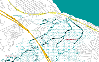
National Hydrography Data SLD posted

From the OGC Public Forum -
"USGS has developed a prototype Styled Layer Descriptor (SLD) for the National Hydrography Data (NHD), available here.
The NHD SLD is based on cartographic specifications, and USGS Symbol libraries were used to render geographic features in a cartographic quality map. Documents 6psym403.pdf and topomapsymbols.pdf were used as templates to generate the SLD encodings for the NHD styles. Descriptions of the development effort and examples are available here and here.
Prototype SLD encodings are available here, and deployed as part of the NSDI WMS."
A few of my favorite map symbols include - Swamp / Marsh, Inundation Areas and others.
SLD is a standard that lets data providers can use the same underlying data to generate different types of maps - like a transparent overlay of hydrography and roads data for a geologic map. Another way to think of it is by asking yourself the question, "how can I make Google Maps look different?" The answer is, "You can't." SLD allows the same underlying data to be symbolized differently.
- Jeff
- Jeff


0 Comments:
Post a Comment
<< Home