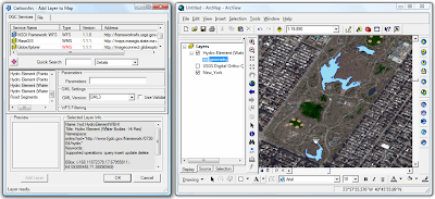
Adding GML features from WFS to ArcMap - easy as a walk in Central Park

People have been contacting us lately about how they can use WFS in ArcMap. Here's an example -
Select the NSDI Framework WFS, change the GML version to GML3 and click on the Hydro Element (Water Bodies - Hi Res) layer. Once the preview is generated add the feature layer to the map. Note that you can alter the polygon styling the same way its done for any other features in ArcMap (CarbonArc uses the native ArcMap symbology in order to render the GML features).
A quick way to alter the symbol is to click on the symbol legend in the layers list. Once the symbol is selected the layer style will be automatically updated.
The following companies provided software or OGC SDI services used in this example - USGS, ESRI, CubeWerx, Digital Globe and geoLeaders.
- Jeff


0 Comments:
Post a Comment
<< Home